|
|
Hurricane Hugo Facts
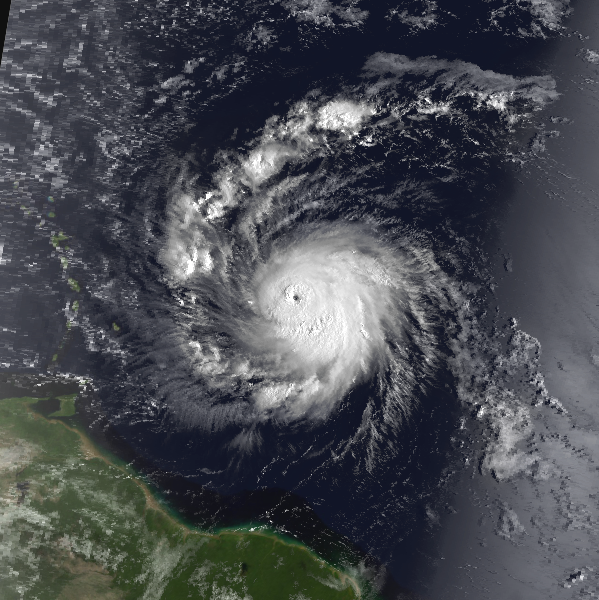
Hurricane Hugo over the open Atlantic
Hurricane Hugo was one the strongest and costliest hurricanes to affect the United States and Caribbean. It was first identified as a group of thunderstorms near the west coast of Africa on September 9th, 1989. The following day it was classified as a tropical depression southeast of the Cape Verde Islands and then a tropical storm on the 11th. Hugo steadily gained strength to hurricane status on the 13th - approximately 1250 miles east of the Leeward islands. The strengthening accelerated and Hugo went through a rapid deepening phase. This is where a hurricane strengthens rapidly over a short period of time. This was the first of three different strengthening phases. Windspeed had increased to 160 mph and pressure dropped to 918 MB on the 15th. During this time Hugo was turning more west northwest around a weakness in the subtropical ridge. This would guide the hurricane toward the Leeward Islands in the Caribbean.
Hurricane Hugo in the Caribbean
The steering currents would take Hurricane Hugo over the northeast Caribbean the following two days. The tropical cyclone weakened some as it approached the Leeward Islands, but was still a very dangerous category 4 hurricane. It passed over the island of Guadeloupe on the 17th. Over 50 poeple lost their lives through the Leewards islands. Guadeloupe suffered severe agricultural losses as most of Banana and sugar cane crop was wiped out. A french navy ship reported a wind gust to 184 mph.
Hugo continued northwest over St. Croix and the eastern tip of Puerto Rico on the 18th. The second drop of pressure occured east of St. Croix, where the pressure was measured at 934 MB. On the Island of Culebra, just east of Puerto Rico a ship's anemometor registered a wind gust of 170 mph. Other wind gusts of 120 mph were noted at Roosevelt Roads, and 92 mph at San Juan Puerto Rico. Puerto Rico also suffered heavy losses to its coffee and banana crops.
Hurricane Hugo Satellite Picture - east of the Lesser Antilles
Hurricane Hugo east of the Bahamas
After moving north of Puerto Rico, Hugo's motion was guided by an upper air low over Georgia and a strengthening subtropical ridge. This took the hurricane on nearly a straight northwest course directly toward the coast of South Carolina. Weakening had occured north of Puerto Rico and the hurricane's top sustained winds dropped to 105 mph on the 19th. The third of three strenghtening phases began about 30 hours before landfall. Pressure began to drop rapidly again and bottomed out at 934 MB. This is a similar pressure reading that was measured during the second strengthening phase near St. Croix. Winds also increased just before landfall. A reconaissance aircraft found that sustained winds were up to 140 mph, making Hurricane Hugo a category four hurricane.
Hurricane Hugo in the United States / Canada
Landfall occuered north of Charleston near Sullivan's Island. This allowed the highest storm tide to be experienced north of Charleston. Winds north of Charleston were blowing onshore driving the highest storm surge north of the city. Strong offshore winds south of the eye minimized storm tide damage. The heaviest rainfall occured south of where Hugo's eye crossed land. From Charleston south to near Savannah, Georgia 5-10 inches of rainfall was reported. Edisto, Beach, South Carolina measured 10.28 inches.
Winds gusted to 108 mph in Charleston, and 107 mph on Folly Beach. A ship anchored near Georgetown recorded a gust to 120 mph. Storm tides were highest near McClennansville, South Carolina at 20.2 feet.
Hugo's track took it through the central Appalchians and into southeastern Canada. Along the path, heavy rainfall and strong winds caused massive amounts of tree damage and downed power lines. Charlotte, NC reported a wind gust to 99 mph.
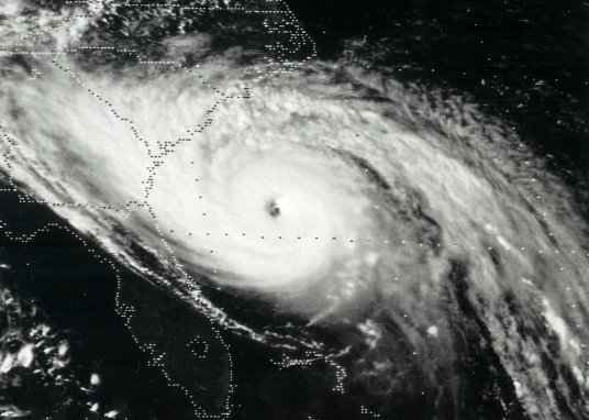
Hurricane Hugo Satellite Picture - southeast of Charleston, SC
Images / data courtesty of the National Hurricane Center / NOAA / NASA
Hurricane Hugo summary
Hurricane Hugo was responsible for over 100 deaths in the Caribbean and United States. It caused approximately eight and a half billion dollars in damage in the United States, Puerto Rico and Virgin Islands. Parts of the Leewards sustained at least an addition billion dollars in damage. It was the costliest hurricane to affect the United States at that time. It now ranks as the eleventh most costly. During its lifetime, Hugo made five landfalls - Guadeloupe, St. Croix, Vieques, Puerto Rico, Fajardo, Puerto Rico and Sullivan's Island, South Carolina. Agricultural loss was experienced in these locations from severe winds. Additionally extensive storm tide damage occured on the coast of South Carolina near and north the of landfall position.
Hurricane Hugo Facts Summary
- Lowest pressure: 918 millibars / 27.11 inches
- Pressure and sustained wind at landfall: 934 millibars / 140 mph
- Maximum sustained winds at peak: 160 mph - category 5 on the Saffir - Simpson scale
- Strongest wind gust in Charleston: 108 mph
- Fatalities: 50 total, 21 mainland U.S.
- U.S. Damage: $7 billion
- U.S. Damage: $14.07 billion - adjusted dollars for 2017
- Caribbean Damage: $3 billion
- Maximum storm surge height: 20 feet, Bulls Bay, SC
- Most intense tropical cyclone to strike the Atlantic coast north of Florida
- USDA Forest Service estimated damage of $100 million to timber north of Charleston
Do you want to find out more about Hurricane Hugo or other hurricanes? Check out our 1980-1989 hurricane summaries.
Back to more hurricane articles.
|
|
|