Page 1 of 1
Imelda
Posted: Sat Sep 27, 2025 7:25 am
by Tropical Inspector
Saturday Morning Update
Tropical Storm Warnings for the north and central Bahamas
Nine was classified last night. It is still disorganized on satellite imagery, but still is producing very heavy showers over the southern Bahamas southward into the Windward passage to far eastern Cuba, western Haiti and Jamaica. Winds are currently gusting below minimal tropical storm strength - 39 mph.
The Weather Situation
SUMMARY OF 800 AM EDT...1200 UTC...INFORMATION
----------------------------------------------
LOCATION...22.0N 75.9W
ABOUT 170 MI...275 KM NW OF THE EASTERN TIP OF CUBA
ABOUT 110 MI...180 KM S OF THE CENTRAL BAHAMAS
MAXIMUM SUSTAINED WINDS...35 MPH...55 KM/H
PRESENT MOVEMENT...NW OR 315 DEGREES AT 7 MPH...11 KM/H
MINIMUM CENTRAL PRESSURE...1005 MB...29.68 INCHES
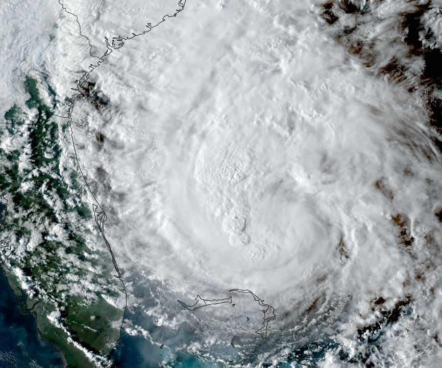
Tropicast: RAMMB/CIRA slider GOES 19 Visible Satellite
 Tropical Weather Forecast:
Tropical depression 9 will be tropical storm Imelda soon. It will move north through the Bahamas and east of the Florida east coast through the weekend. Heavy rainfall and tropical storm force wind gusts can be expected. Forecast models are showing that Imelda will become a hurricane as is moves north, and stall east of the Georgia / South Carolina coast as it interacts with a powerful hurricane Humberto further east. It is then forecast to resume an eastward track east into the Atlantic early next week.

Residents of the SE US coast, especially from eastern Florida north to North Carolina should follow this tropical cyclone and make appropriate preparations.
Re: Tropical depression 9
Posted: Sun Sep 28, 2025 6:20 am
by Tropical Inspector
Sunday Morning Update
Little change overnight
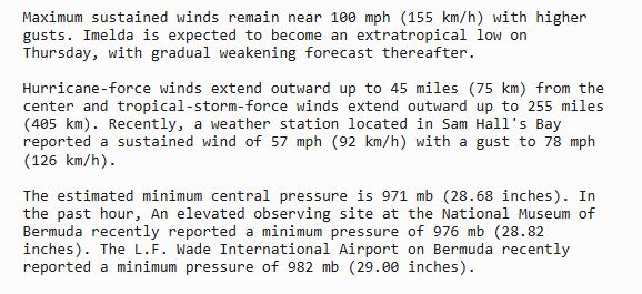
This morning the heaviest showers with tropical depression nine are located over the east central Bahamas. This tropical cyclone is still disorganized, but that should change over the next 24 hours as it drifts north.
The Weather Situation
SUMMARY OF 500 AM EDT...0900 UTC...INFORMATION
----------------------------------------------
LOCATION...23.0N 77.2W
ABOUT 275 MI...440 KM NW OF THE EASTERN TIP OF CUBA
ABOUT 100 MI...160 KM WSW OF THE CENTRAL BAHAMAS
MAXIMUM SUSTAINED WINDS...35 MPH...55 KM/H
PRESENT MOVEMENT...NNW OR 345 DEGREES AT 7 MPH...11 KM/H
MINIMUM CENTRAL PRESSURE...1003 MB...29.62 INCHES
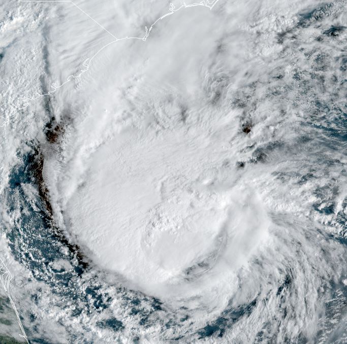
Tropicast: RAMMB/CIRA slider GOES 19 IR Satellite
 Tropical Weather Forecast:
Tropical depression 9 will be tropical storm Imelda soon. It will move north through the Bahamas and east of the Florida east coast into Monday. Heavy rainfall and tropical storm force wind gusts can be expected. Forecast models are showing that Imelda will become a hurricane as is moves north, and stall east of the north Florida coast as it interacts with a powerful hurricane Humberto further east. It is then forecast to resume an eastward track east into the Atlantic Tuesday and Wednesday.
Residents of the SE US coast, especially from eastern Florida north to North Carolina should follow this tropical cyclone and make appropriate preparations.
Re: Imelda
Posted: Sun Sep 28, 2025 2:20 pm
by Tropical Inspector
Sunday Afternoon Update
Imelda now a tropical storm
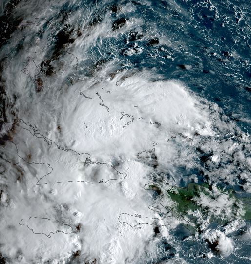
Satellite imagery now clearly show a circulation near Andros Island in the west central Bahamas. Heavy showers should begin to expand over the northern Bahamas later today into Monday.
The Weather Situation
SUMMARY OF 200 PM EDT...1800 UTC...INFORMATION
----------------------------------------------
LOCATION...23.9N 77.3W
ABOUT 95 MI...155 KM WNW OF THE CENTRAL BAHAMAS
ABOUT 370 MI...600 KM SE OF CAPE CANAVERAL FLORIDA
MAXIMUM SUSTAINED WINDS...40 MPH...65 KM/H
PRESENT MOVEMENT...N OR 355 DEGREES AT 7 MPH...11 KM/H
MINIMUM CENTRAL PRESSURE...998 MB...29.47 INCHES
Tropicast: RAMMB/CIRA slider GOES 19 IR Satellite
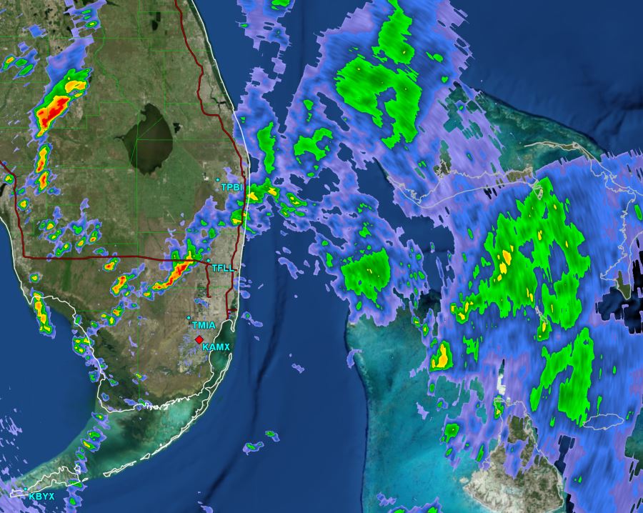
 Tropicast: Miami, FL Radar GR Level 3 3:30 pm EDT
 Tropical Weather Forecast:
Tropcial storm Imelda will move north through the Bahamas and east of the Florida east coast into Monday. Heavy rainfall and tropical storm force wind gusts can be expected. Forecast models are showing that Imelda will become a hurricane as is moves north, and stall east of the north Florida coast as it interacts with a powerful hurricane Humberto further east. It is then forecast to resume an eastward track east into the Atlantic Tuesday and Wednesday.
Residents on the Space coast of Florida should prepare for tropical storm force wind gusts and scattered, heavy showers.
Re: Imelda
Posted: Mon Sep 29, 2025 5:43 pm
by Tropical Inspector
Monday Evening Update
Imelda pulling away from Florida east coast
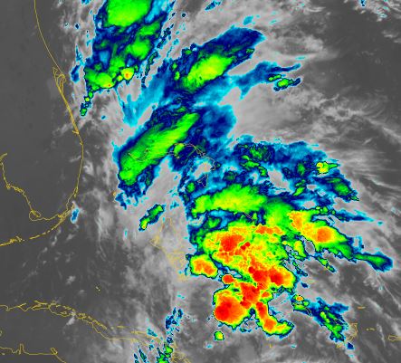
Imelda is organizing this evening and the heaviest showers and storms are moving away from the east coast of Florida and northern Bahamas. Imelda will likely become a hurricane later tonight or Tuesday morning.
The Weather Situation
SUMMARY OF 500 PM EDT...2100 UTC...INFORMATION
----------------------------------------------
LOCATION...27.7N 77.3W
ABOUT 90 MI...145 KM N OF GREAT ABACO ISLAND
ABOUT 205 MI...335 KM ESE OF CAPE CANAVERAL FLORIDA
MAXIMUM SUSTAINED WINDS...65 MPH...100 KM/H
PRESENT MOVEMENT...N OR 360 DEGREES AT 9 MPH...15 KM/H
MINIMUM CENTRAL PRESSURE...986 MB...29.12 INCHES
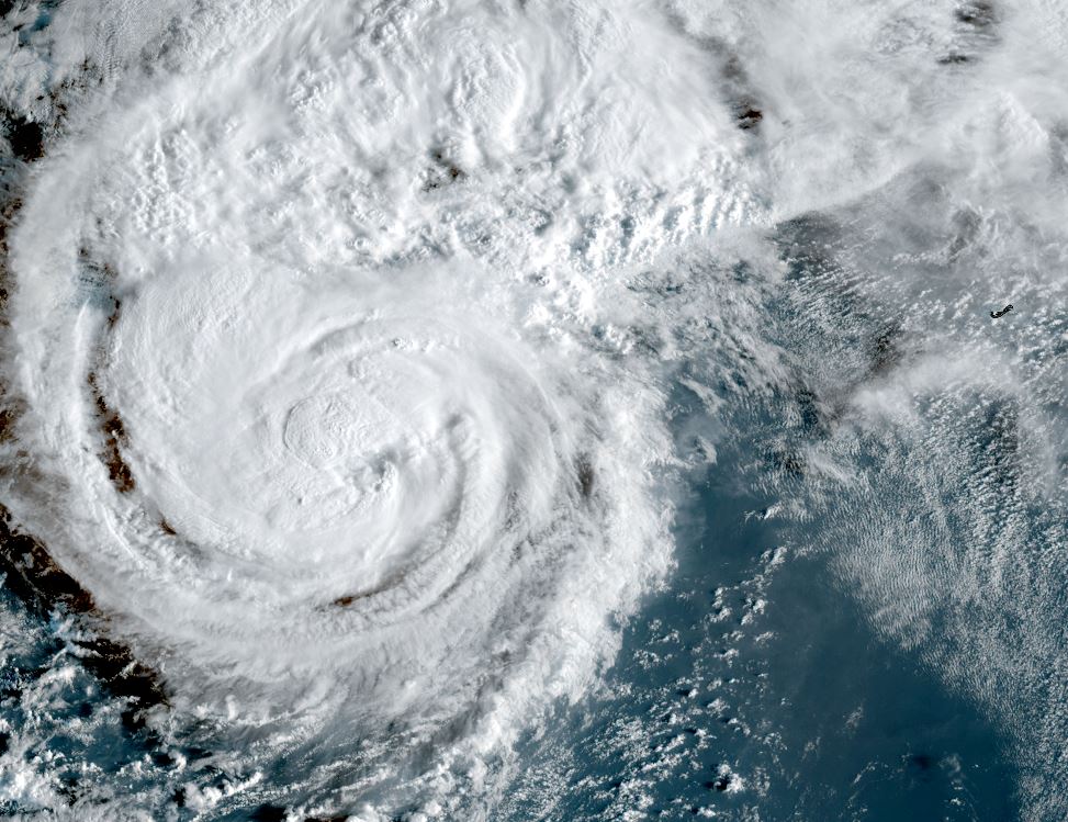
Tropicast: RAMMB/CIRA slider GOES 19 Visible Satellite
 Tropical Weather Forecast:
Imelda is interacting with hurricane Humberto to the east. Humberto's strong circulation essentially has stopped the northern motion of Imelda and it will follow eastward. Imdela will be very close or move over Bermuda Wednesday night.
Residents of Bermuda will see Humberto pass to the west tomorrow, but a more significant effects will come from Imelda as strong winds, and heavy heavy rain can be expected. A hurricane watch is in effect for Bermuda from Imelda.
Re: Imelda
Posted: Tue Sep 30, 2025 11:35 am
by Tropical Inspector
Tuesday Afternoon Update
Imelda now a hurricane
Imelda continues to pull away from the Bahamas and SE US coast today. The main effects seen will be high surf from Imelda and Humberto.
The Weather Situation
SUMMARY OF 1100 AM EDT...1500 UTC...INFORMATION
-----------------------------------------------
LOCATION...29.1N 76.6W
ABOUT 735 MI...1180 KM WSW OF BERMUDA
MAXIMUM SUSTAINED WINDS...80 MPH...130 KM/H
PRESENT MOVEMENT...NE OR 40 DEGREES AT 7 MPH...11 KM/H
MINIMUM CENTRAL PRESSURE...980 MB...28.94 INCHES
Tropicast: RAMMB/CIRA slider GOES 19 Visible Satellite
 Tropical Weather Forecast:
Imelda is interacting with hurricane Humberto to the east. Imelda will be very close or move over Bermuda Wednesday evening.
Residents of Bermuda will see Humberto pass to the west tomorrow, but a more significant effects will come from Imelda as strong winds, and heavy heavy rain can be expected. A hurricane watch is in effect for Bermuda from Imelda.
Re: Imelda
Posted: Wed Oct 01, 2025 7:43 am
by Tropical Inspector
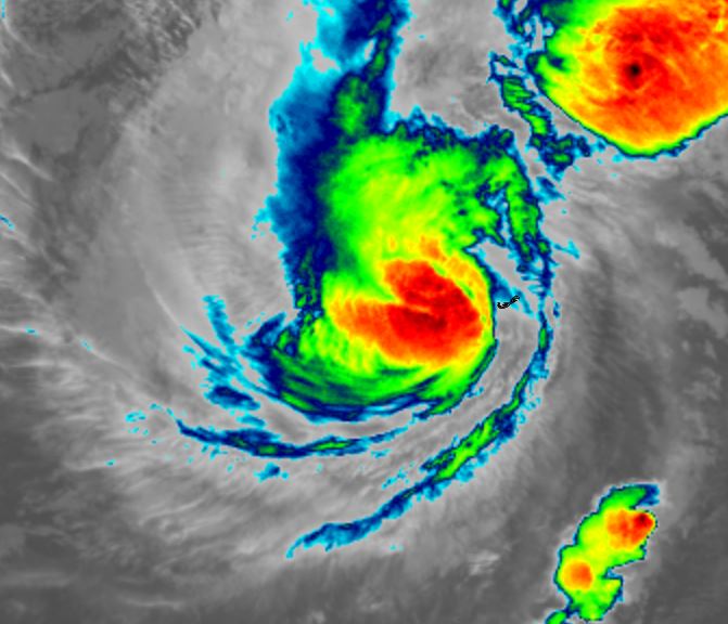
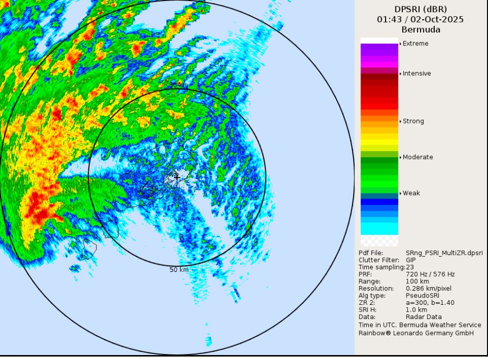
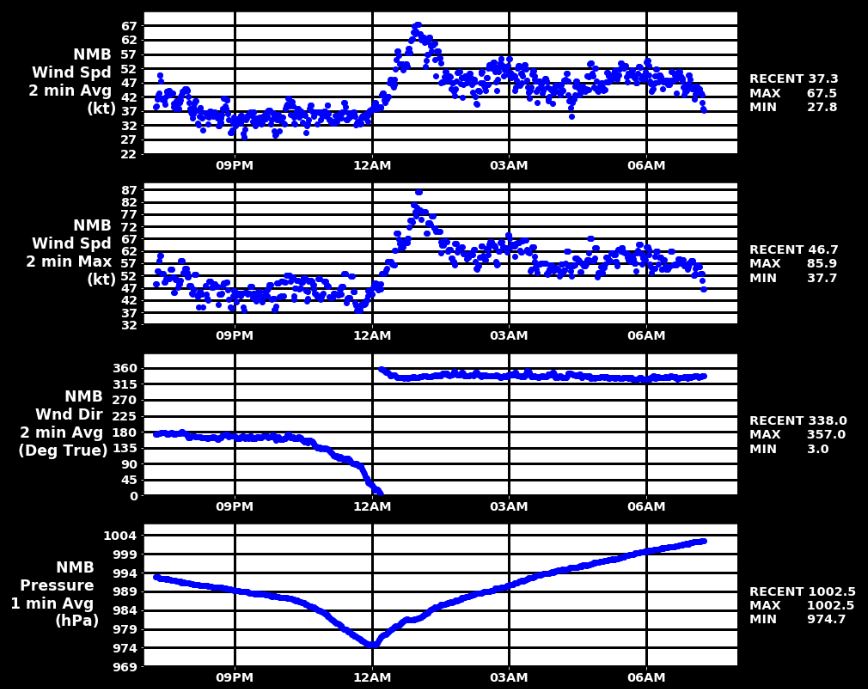
Wednesday Morning Update
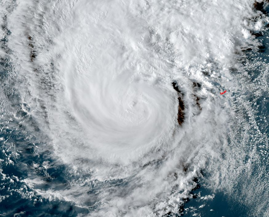
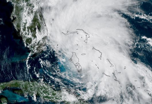
Imelda approaching Bermuda
Imelda will pass very close to Bermuda later today. The eye could possibly pass over or just to the south. Winds gusting to hurricane force, large surf and heavy rainfall which can produce flash flooding can be expected.
The Weather Situation
SUMMARY OF 800 AM EDT...1200 UTC...INFORMATION
----------------------------------------------
LOCATION...30.7N 71.3W
ABOUT 395 MI...640 KM WSW OF BERMUDA
MAXIMUM SUSTAINED WINDS...90 MPH...150 KM/H
PRESENT MOVEMENT...ENE OR 70 DEGREES AT 21 MPH...33 KM/H
MINIMUM CENTRAL PRESSURE...974 MB...28.77 INCHES
Tropicast: RAMMB/CIRA slider GOES 19 Visible Satellite
 Tropical Weather Forecast:
Imelda will move east of Bermuda and become extratropical.
A hurricane warning is in effect for Bermuda from Imelda.
Re: Imelda
Posted: Thu Oct 02, 2025 5:35 am
by Tropical Inspector