Page 1 of 1
Gabrielle
Posted: Wed Sep 17, 2025 8:05 am
by Tropical Inspector
Wednesday Morning Update
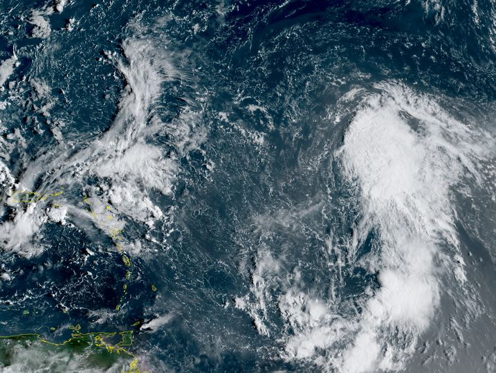
TD 7
A large circulation exists with TD 7 with accompanying deep convection. This system is likely a tropical storm and should be classified as one on the next official NHC advisory
The Weather Situation
SUMMARY OF 500 AM AST...0900 UTC...INFORMATION
----------------------------------------------
LOCATION...13.7N 45.9W
ABOUT 1185 MI...1905 KM ESE OF THE NORTHERN LEEWARD ISLANDS
MAXIMUM SUSTAINED WINDS...35 MPH...55 KM/H
PRESENT MOVEMENT...W OR 280 DEGREES AT 13 MPH...20 KM/H
MINIMUM CENTRAL PRESSURE...1007 MB...29.74 INCHES
Tropicast: RAMMB/CIRA slider GOES 19 Visible Satellite
 Tropical Weather Forecast:
TD 7 is organizing and will move NW, east of the lesser antilles and likely stay well east of the US coast next week.
Re: Gabrielle
Posted: Wed Sep 17, 2025 6:21 pm
by Tropical Inspector
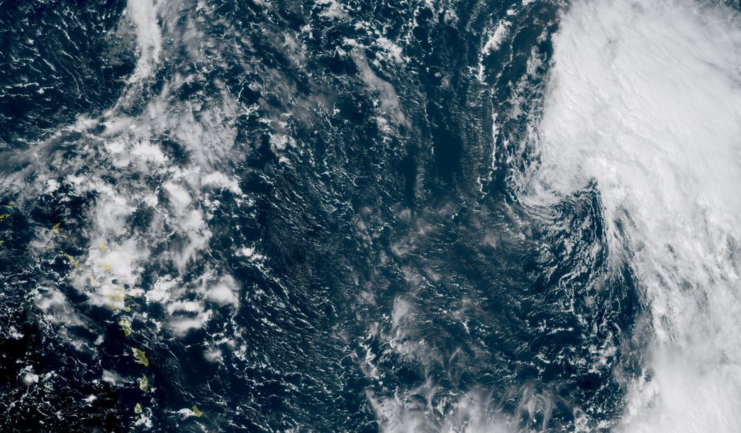
Wednesday Evening Update
Gabrielle being sheared
Visible satellite has shown that deep convection remains NE of the circulation center. Southwesterly wind shear is keeping deep convection away from the center which will inhibit development for a few days.
The Weather Situation
SUMMARY OF 500 PM AST...2100 UTC...INFORMATION
----------------------------------------------
LOCATION...19.4N 48.0W
ABOUT 990 MI...1595 KM E OF THE NORTHERN LEEWARD ISLANDS
MAXIMUM SUSTAINED WINDS...50 MPH...85 KM/H
PRESENT MOVEMENT...NW OR 310 DEGREES AT 14 MPH...22 KM/H
MINIMUM CENTRAL PRESSURE...1005 MB...29.68 INCHES
Tropicast: RAMMB/CIRA slider GOES 19 Visible Satellite
 Tropical Weather Forecast:
Gabrielle will move NW, east of the Lesser Antilles and likely stay well east of the US coast next week. It will struggle for a few days as it fights wind shear. It may be in the vicinity of Bermuda by Monday.
Re: Gabrielle
Posted: Thu Sep 18, 2025 9:22 am
by Tropical Inspector
Thursday Morning Update
Gabrielle weakens
Visible satellite has shown that Gabrielle has been sheared badly from SW wind shear and dry air. No deep convection remains near the center and the 5 am wind estimation imo is considerably too high.
The Weather Situation
SUMMARY OF 500 AM AST...0900 UTC...INFORMATION
----------------------------------------------
LOCATION...20.0N 50.3W
ABOUT 845 MI...1360 KM E OF THE NORTHERN LEEWARD ISLANDS
MAXIMUM SUSTAINED WINDS...50 MPH...85 KM/H
PRESENT MOVEMENT...WNW OR 300 DEGREES AT 15 MPH...24 KM/H
MINIMUM CENTRAL PRESSURE...1004 MB...29.65 INCHES
Tropicast: RAMMB/CIRA slider GOES 19 Visible Satellite
 Tropical Weather Forecast:
Gabrielle will move NW, east of the Lesser Antilles and likely stay well east of the US coast next week. It will struggle for a few days as it fights wind shear. It may be in the vicinity of Bermuda by Monday.
Re: Gabrielle
Posted: Fri Sep 19, 2025 4:20 am
by Tropical Inspector
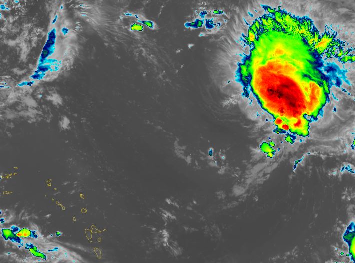
Friday Morning Update
Gabrielle is more organized
IR satellite imagery indicates that a large area of convection has built near and east of the circulation center. Even though it continues to fight westerly wind shear, it is beginning to weaken. For the first time in about 36 hours imo the 50 mph official wind estimate seems reasonable.
The Weather Situation
SUMMARY OF 500 AM AST...0900 UTC...INFORMATION
----------------------------------------------
LOCATION...21.9N 54.8W
ABOUT 595 MI...960 KM ENE OF THE NORTHERN LEEWARD ISLANDS
ABOUT 945 MI...1520 KM SE OF BERMUDA
MAXIMUM SUSTAINED WINDS...50 MPH...85 KM/H
PRESENT MOVEMENT...WNW OR 300 DEGREES AT 12 MPH...19 KM/H
MINIMUM CENTRAL PRESSURE...1004 MB...29.65 INCHES
Tropicast: RAMMB/CIRA slider GOES 19 IR Satellite
 Tropical Weather Forecast:
Gabrielle is continuing generally NW, well to the NE of the Lesser Antilles. Models have trended slightly east recently which would take Gabrielle east of Bermuda by Monday. Interests in Bermuda should continue to follow the progress of this tropical cyclone.
Re: Gabrielle
Posted: Mon Sep 22, 2025 1:32 pm
by Tropical Inspector
Monday Afternoon Update
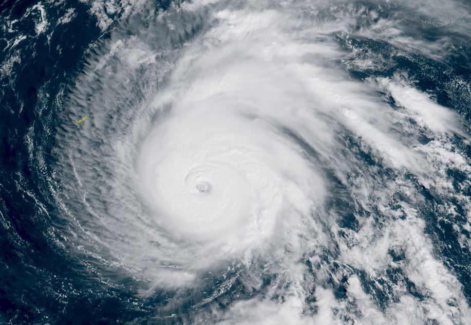
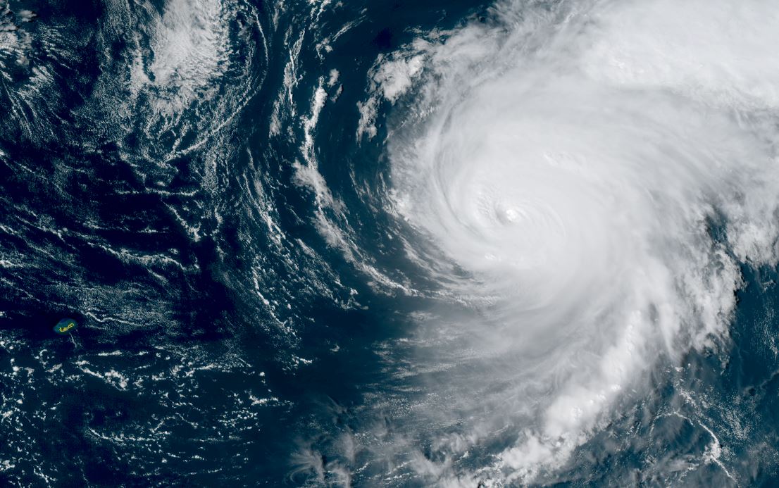
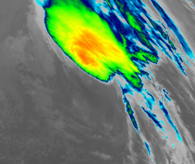
Gabrielle is considerably stronger
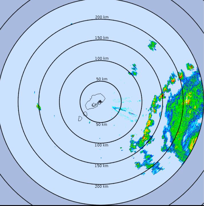
Visible satellite imagery shows that Gabrielle is now a classic looking hurricane with a distinct eye and strong outflow. Yesterday the eye was forming and this trend of organization has continued today. Gabrielle may continue to strengthen as it moves east, away from Bermuda. Bermuda radar shows an outer band slightly more than 100km (60 mi) to the east.
The Weather Situation
SUMMARY OF 1100 AM AST...1500 UTC...INFORMATION
-----------------------------------------------
LOCATION...30.8N 62.3W
ABOUT 180 MI...290 KM SE OF BERMUDA
MAXIMUM SUSTAINED WINDS...120 MPH...195 KM/H
PRESENT MOVEMENT...N OR 10 DEGREES AT 10 MPH...17 KM/H
MINIMUM CENTRAL PRESSURE...955 MB...28.20 INCHES
Tropicast: RAMMB/CIRA slider GOES 19 visible Satellite Monday Afternoon
 Tropicast: RAMMB/CIRA slider GOES 19 Visible Satellite Sunday Afternoon
 Tropicast: Bermuda Weather Service Radar 2:25 PM AST
 Tropical Weather Forecast:
Gabrielle will track NE the next 24 hours then turn more ENE as it moves away from Bermuda. It may pass close to the western Azores Friday. Interests in the Azores should continue to follow the progress of Gabrielle.
Re: Gabrielle
Posted: Mon Sep 22, 2025 5:23 pm
by Tropical Inspector
Monday Evening Update
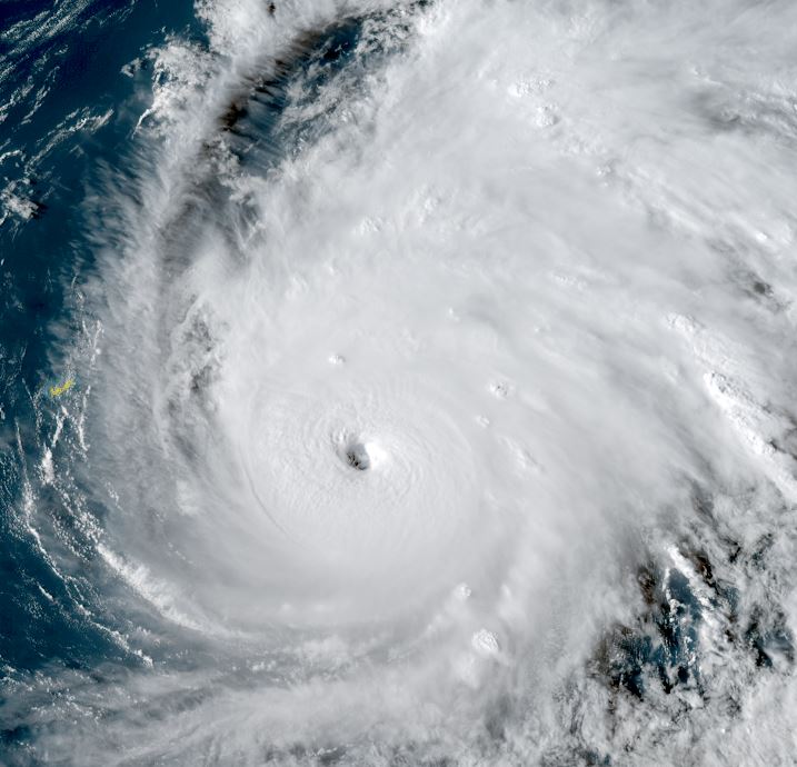
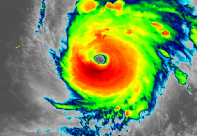
Gabrielle now a cat 4
Satellite imagery shows increased intensification. The IR indicates the thickest eyewall to the south with a weakness on the NW sector. There may be fluctuation in strength over the next day with eyewall replacement cycles.
The Weather Situation
SUMMARY OF 500 PM AST...2100 UTC...INFORMATION
----------------------------------------------
LOCATION...31.7N 61.8W
ABOUT 180 MI...290 KM ESE OF BERMUDA
ABOUT 2005 MI...3230 KM W OF THE AZORES
MAXIMUM SUSTAINED WINDS...140 MPH...220 KM/H
PRESENT MOVEMENT...NNE OR 20 DEGREES AT 12 MPH...19 KM/H
MINIMUM CENTRAL PRESSURE...948 MB...28.00 INCHES
Tropicast: RAMMB/CIRA slider GOES 19 Visible Satellite Late Afternoon
 Tropicast: RAMMB/CIRA slider GOES 19 IR Satellite late Afternoon
 Tropical Weather Forecast:
Gabrielle will track NE the next 24 hours then turn more ENE as it moves away from Bermuda. It may pass close to the western Azores Friday. Interests in the Azores should continue to follow the progress of Gabrielle.
Re: Gabrielle
Posted: Tue Sep 23, 2025 2:12 pm
by Tropical Inspector
Tuesday Afternoon Update
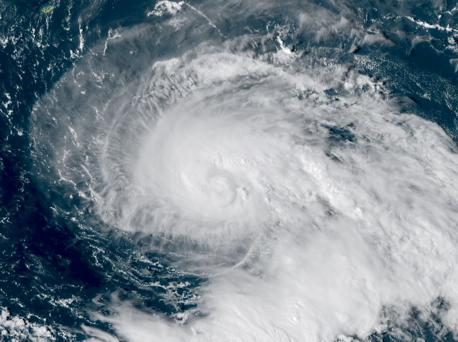
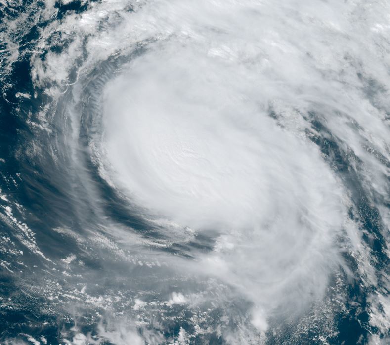
Gabrielle moving east
Satellite imagery shows that Gabrielle is moving mostly east now. The eye has clouded over and a slow trend toward weakening has begun. Dry air and westerly shear also is noticed with the western portion of the circulation losing convection. Top sustained winds imo are a bit lower than the 130 mph estimated.
The Weather Situation
SUMMARY OF 200 PM AST...1800 UTC...INFORMATION
----------------------------------------------
LOCATION...34.3N 57.5W
ABOUT 445 MI...715 KM ENE OF BERMUDA
ABOUT 1710 MI...2755 KM W OF THE AZORES
MAXIMUM SUSTAINED WINDS...130 MPH...215 KM/H
PRESENT MOVEMENT...ENE OR 60 DEGREES AT 20 MPH...31 KM/H
MINIMUM CENTRAL PRESSURE...952 MB...28.12 INCHES
Tropicast: RAMMB/CIRA slider GOES 19 Visible Satellite
 Tropical Weather Forecast:
Gabrielle is now forecast to pass over the western / central Azores later on Thursday. Interests in the Azores should continue to follow the progress of Gabrielle and take appropriate actions.
Re: Gabrielle
Posted: Wed Sep 24, 2025 5:14 pm
by Tropical Inspector
Wednesday Evening Update
Gabrielle moving toward the Azores
Satellite imagery this afternoon no longer shows and eye as it is totally clouded over. Winds continue to steadily drop, but will still likely be in the category 1 range as it moves over the Azores in a little over 24 hours.
The Weather Situation
SUMMARY OF 500 PM AST...2100 UTC...INFORMATION
----------------------------------------------
LOCATION...36.0N 45.2W
ABOUT 1010 MI...1630 KM W OF THE AZORES
MAXIMUM SUSTAINED WINDS...100 MPH...155 KM/H
PRESENT MOVEMENT...E OR 80 DEGREES AT 28 MPH...44 KM/H
MINIMUM CENTRAL PRESSURE...970 MB...28.65 INCHES
Tropicast: RAMMB/CIRA slider GOES 19 Visible Satellite
 Tropical Weather Forecast:
Gabrielle is now forecast to pass over the Azores later on Thursday night / early Friday morning. Winds may gust to hurricane strength as it passes by. Interests in the Azores should continue to follow the progress of Gabrielle and take appropriate actions.
Re: Gabrielle
Posted: Thu Sep 25, 2025 1:44 pm
by Tropical Inspector
Thurday Afternoon Update
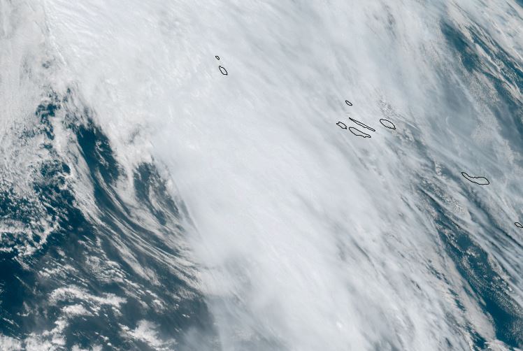
Gabrielle closing in on the Azores
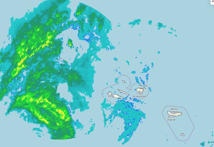
Gabrielle is sheared and the western side of the circulation has little convection. Heavy showers, especially before the center arrives and gusts to hurricane strength may be seen. Tropical storm force winds are likely. Radar shows heavy rain approaching from the west.
The Weather Situation
SUMMARY OF 600 PM GMT...1800 UTC...INFORMATION
----------------------------------------------
LOCATION...36.7N 33.8W
ABOUT 385 MI...620 KM W OF THE AZORES
MAXIMUM SUSTAINED WINDS...75 MPH...120 KM/H
PRESENT MOVEMENT...E OR 80 DEGREES AT 31 MPH...50 KM/H
MINIMUM CENTRAL PRESSURE...982 MB...29.00 INCHES
Tropicast: RAMMB/CIRA slider GOES 19 Visible Satellite
 Tropicast: Azores Radar 6:45 pm GMT / 2:45 pm EDT
 Tropical Weather Forecast:
Gabrielle will pass over the Azores later this evening into early Friday morning. Winds may gust to hurricane strength as it passes by. Interests in the Azores should have completed appropriate actions.
Re: Gabrielle
Posted: Thu Sep 25, 2025 7:56 pm
by Tropical Inspector
Thurday Night Update
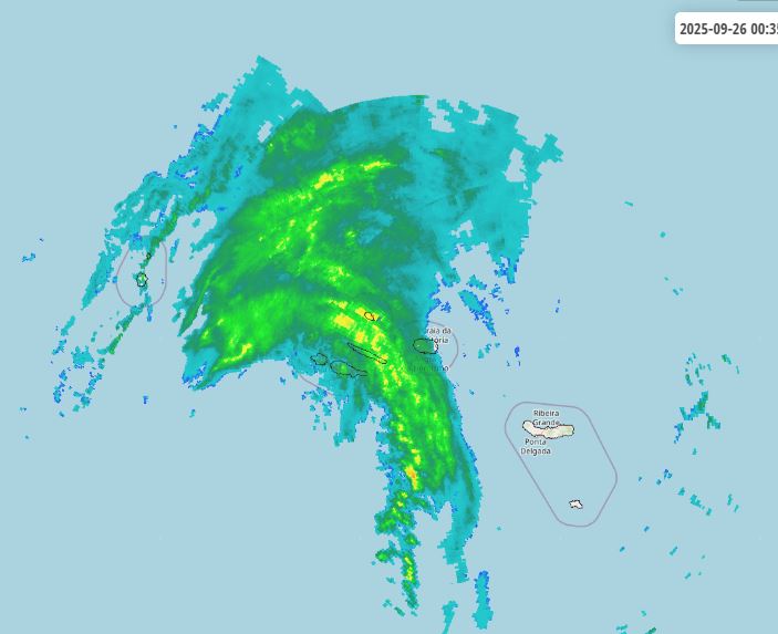
Gabrielle near the Azores
The center of post tropical Gabrielle is still west of the Azores, but the heaviest rainband is now moving through the central islands with the strongest winds.
The Weather Situation
SUMMARY OF 1200 AM GMT...0000 UTC...INFORMATION
-----------------------------------------------
LOCATION...37.6N 30.5W
ABOUT 120 MI...195 KM SW OF FAIAL ISLAND IN THE CENTRAL AZORES
MAXIMUM SUSTAINED WINDS...70 MPH...110 KM/H
PRESENT MOVEMENT...ENE OR 75 DEGREES AT 30 MPH...48 KM/H
MINIMUM CENTRAL PRESSURE...983 MB...29.03 INCHES
Tropicast: RAMMB/CIRA slider GOES 19 IR Satellite
 Tropicast: Azores Radar 12:50 am GMT Friday / 8:50 pm EDT Thursday
 Tropical Weather Forecast:
Gabrielle will continue as a post tropical system toward Portugal over the next few days.
NHC Advisory
https://www.nhc.noaa.gov/text/refresh/M ... 343.shtml?
NHC Track
https://www.nhc.noaa.gov/refresh/graphi ... e#contents