Page 1 of 1
Kiko
Posted: Mon Sep 01, 2025 7:26 pm
by Tropical Inspector
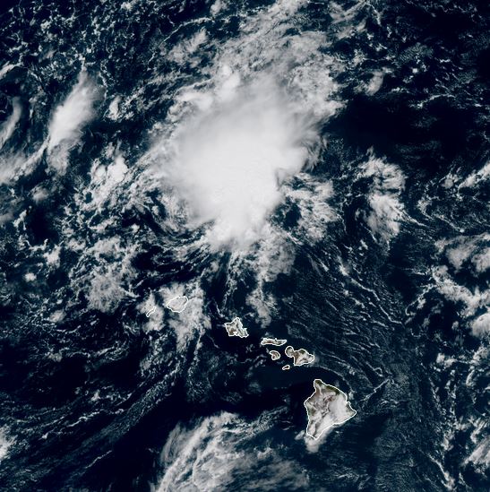
Monday Evening Update
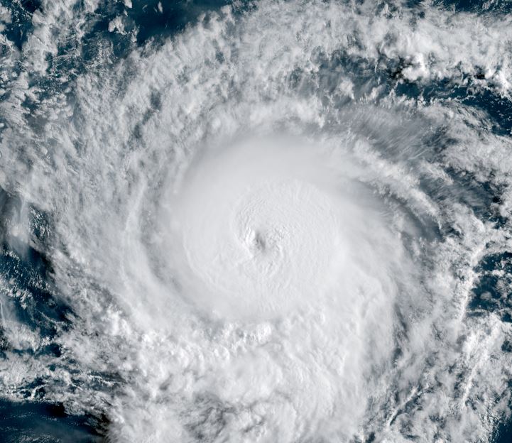
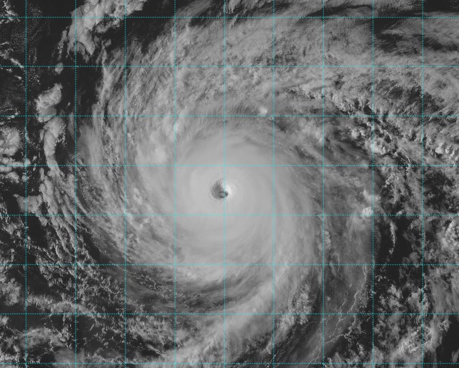
Kiko almost a hurricane
Satellite imagery shows a temporary eye like structure and deepening convection. Kiko may be upgraded to hurricane strength on the next official advisory.
The Weather Situation
SUMMARY OF 1100 AM HST...2100 UTC...INFORMATION
-----------------------------------------------
LOCATION...13.8N 126.7W
ABOUT 1265 MI...2035 KM WSW OF THE SOUTHERN TIP OF BAJA CALIFORNIA
MAXIMUM SUSTAINED WINDS...65 MPH...100 KM/H
PRESENT MOVEMENT...WSW OR 255 DEGREES AT 7 MPH...11 KM/H
MINIMUM CENTRAL PRESSURE...999 MB...29.50 INCHES
Tropicast: Visible RAMMB/CIRA slider
 Tropical Weather Forecast:
Kiko will move generally WNW the next several days over the open waters of the eastern north pacific.
Re: Kiko
Posted: Tue Sep 02, 2025 4:31 pm
by Tropical Inspector
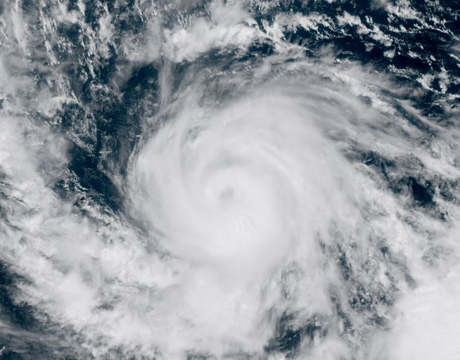
Tuesday Late Afternoon Update
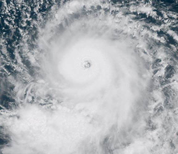
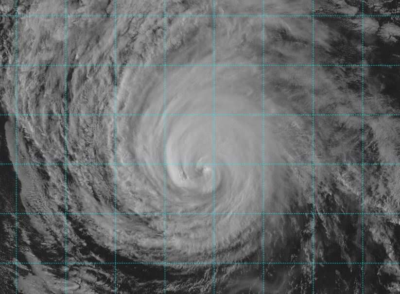
Kiko increasing in strength
Visible satellite shows a solid eyewall around the eye of hurricane Kiko. Conditions favor continued intensification.
The Weather Situation
SUMMARY OF 1100 AM HST...2100 UTC...INFORMATION
-----------------------------------------------
LOCATION...13.9N 128.9W
ABOUT 1775 MI...2855 KM E OF HILO HAWAII
MAXIMUM SUSTAINED WINDS...100 MPH...155 KM/H
PRESENT MOVEMENT...W OR 270 DEGREES AT 6 MPH...9 KM/H
MINIMUM CENTRAL PRESSURE...980 MB...28.94 INCHES
Tropicast: Visible RAMMB/CIRA slider GOES 18
 Tropical Weather Forecast:
Kiko is moving west then turn move WNW in a few days as it continues to strengthen over the open waters of the eastern north pacific.
Re: Kiko
Posted: Wed Sep 03, 2025 6:05 pm
by Tropical Inspector
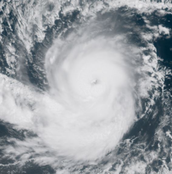
Wednesday Late Afternoon Update
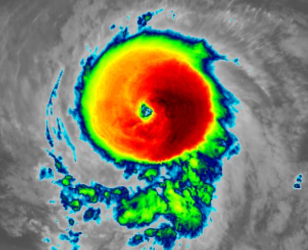
Kiko is a classic hurricane
Satellite imagery shows strong outflow aloft and an eye surrounded by a solid eyewall.... in other words - a classic looking hurricane. Kiko is now estimated to be a category 4.
The Weather Situation
SUMMARY OF 1100 AM HST...2100 UTC...INFORMATION
-----------------------------------------------
LOCATION...13.9N 131.6W
ABOUT 1600 MI...2580 KM E OF HILO HAWAII
MAXIMUM SUSTAINED WINDS...130 MPH...215 KM/H
PRESENT MOVEMENT...W OR 270 DEGREES AT 9 MPH...15 KM/H
MINIMUM CENTRAL PRESSURE...955 MB...28.20 INCHES
Tropicast: Visible RAMMB/CIRA slider GOES 18
 Tropical Weather Forecast:
Kiko is moving west then turn more WNW in a few days. It may strengthen a little more before making that turn to WNW in the next day over the open waters of the eastern north pacific. It will be still east of the Big Island by Monday morning.
Re: Kiko
Posted: Thu Sep 04, 2025 12:36 pm
by Tropical Inspector
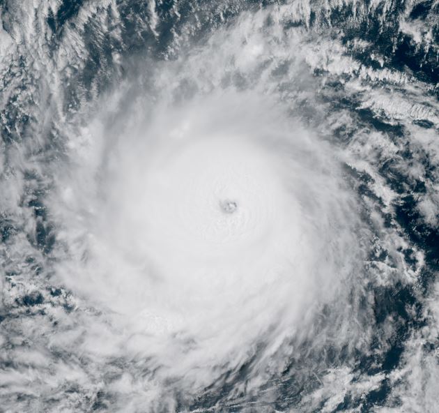
Thursday Afternoon Update
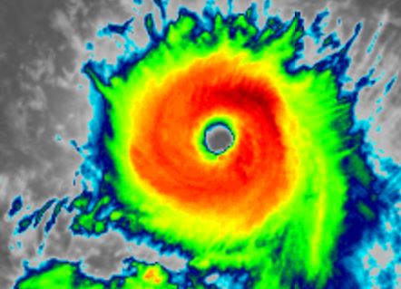
Kiko staying strong
On this morning - Hawaiian time - IR imagery shows a thick, well developed eyewall indicative of a mature hurricane. Some fluctuations in strength are likely until a weakening trend starts in a few days.
The Weather Situation
SUMMARY OF 500 AM HST...1500 UTC...INFORMATION
----------------------------------------------
LOCATION...13.8N 133.7W
ABOUT 1470 MI...2365 KM ESE OF HILO HAWAII
ABOUT 1675 MI...2690 KM ESE OF HONOLULU HAWAII
MAXIMUM SUSTAINED WINDS...130 MPH...215 KM/H
PRESENT MOVEMENT...W OR 270 DEGREES AT 9 MPH...15 KM/H
MINIMUM CENTRAL PRESSURE...951 MB...28.09 INCHES
Tropicast: Visible RAMMB/CIRA slider GOES 18
 Tropicast: IR RAMMB/CIRA slider GOES 18
 Tropical Weather Forecast:
Kiko is forecast to move WNW - NW over the next several days east of the Big Island. It will remain as a strong hurricane for another few days and begin weakening as it approaches the Big Island. It will be a little NE of the Big Island by Monday morning.
Re: Kiko
Posted: Fri Sep 05, 2025 4:34 pm
by Tropical Inspector
Friday Afternoon Update
Kiko staying strong
On this morning - Hawaiian time - IR imagery continues to show an impressive eyewall. Yesterday it was much thicker and cloud tops colder indicating a bit stronger. Since that time weakening occurred and now restrengthening again as the eye clears. This reorganizing phase may continue into Saturday before it approaches closer to the Big Island
The Weather Situation
SUMMARY OF 1100 AM HST...2100 UTC...INFORMATION
-----------------------------------------------
LOCATION...14.5N 137.8W
ABOUT 1195 MI...1925 KM ESE OF HILO HAWAII
ABOUT 1400 MI...2255 KM ESE OF HONOLULU HAWAII
MAXIMUM SUSTAINED WINDS...130 MPH...215 KM/H
PRESENT MOVEMENT...WNW OR 290 DEGREES AT 10 MPH...17 KM/H
MINIMUM CENTRAL PRESSURE...951 MB...28.09 INCHES
Tropicast: Visible RAMMB/CIRA slider GOES 18
 Tropicast: IR RAMMB/CIRA slider GOES 18
 Tropical Weather Forecast:
Kiko is forecast to move WNW - NW over the next several days east of the Big Island. It will remain as a strong hurricane for another few days and begin weakening as it approaches the Big Island. It will be a little NE of the Big Island by Tuesday morning with models continuing the track to the north of the Islands.

At this time the main effects appear to be higher than normal surf and rip tides, especially on the eastern and northern facing beaches. Interests in the Hawaiian Island should monitor the track of Kiko for any changes.
Re: Kiko
Posted: Sat Sep 06, 2025 8:29 pm
by Tropical Inspector
Saturday Evening Update
Kiko still a major hurricane
On this afternoon - Hawaiian time - Kiko continues some fluctuations in strength, but remains a category 3 hurricane. High surf from large swell will begin to arrive on the eastern part of the Hawaiian islands Sunday.
The Weather Situation
SUMMARY OF 150 PM HST...2350 UTC...INFORMATION
----------------------------------------------
LOCATION...16.3N 141.8W
ABOUT 900 MI...1450 KM ESE OF HILO HAWAII
ABOUT 1110 MI...1780 KM ESE OF HONOLULU HAWAII
MAXIMUM SUSTAINED WINDS...125 MPH...200 KM/H
PRESENT MOVEMENT...WNW OR 295 DEGREES AT 12 MPH...19 KM/H
MINIMUM CENTRAL PRESSURE...951 MB...28.09 INCHES
Tropicast: Visible GOES 18
 Tropical Weather Forecast:
Kiko is forecast to move WNW - NW to northeast of the Big Island by Monday. It will begin weakening as is approaches and tracks to the north of the Islands into next week.
At this time the main effects appear to be higher than normal surf and rip tides, especially on the eastern and northern facing beaches. Interests in the Hawaiian Island should monitor the track of Kiko for any changes.
Re: Kiko
Posted: Sun Sep 07, 2025 9:11 pm
by Tropical Inspector
Sunday Evening Update
Kiko weakening
On this late afternoon - Hawaiian time - Kiko is showing signs of weakening. Convection associated with the eye wall is not as extensive nor the cloud tops as high. Pressure measured from the reconnaissance aircraft also is much higher. This all points to weakening and the official estimate is likely fairly generous for top wind speed. High swell on the northern and eastern facing beaches will be the primary concern.
The Weather Situation
SUMMARY OF 1100 AM HST...2100 UTC...INFORMATION
-----------------------------------------------
LOCATION...18.1N 145.5W
ABOUT 635 MI...1025 KM E OF HILO HAWAII
ABOUT 835 MI...1345 KM ESE OF HONOLULU HAWAII
MAXIMUM SUSTAINED WINDS...110 MPH...175 KM/H
PRESENT MOVEMENT...WNW OR 300 DEGREES AT 13 MPH...20 KM/H
MINIMUM CENTRAL PRESSURE...974 MB...28.77 INCHES
Tropicast: Visible GOES 18
 Tropical Weather Forecast:
Kiko is forecast to weaken to a tropical storm Monday and track north parallel to the Islands into next week.
At this time the main effects appear to be higher than normal surf and rip tides, especially on the eastern and northern facing beaches. Interests in the Hawaiian Island should monitor the track of Kiko for any changes.
Re: Kiko
Posted: Mon Sep 08, 2025 7:01 pm
by Tropical Inspector
Monday Evening Update
Kiko trends further weakening
On this afternoon - Hawaiian time - Satellite imagery shows a continued slow weakening as Kiko is fighting shear and weakening. The latest reconnaissance aircraft report shows winds near hurricane strength at flight level, but IMO are probably lower. It is expected that Kiko will be downgraded to a tropical storm soon.
The Weather Situation
SUMMARY OF 1100 AM HST...2100 UTC...INFORMATION
-----------------------------------------------
LOCATION...21.0N 149.9W
ABOUT 350 MI...560 KM ENE OF HILO HAWAII
ABOUT 515 MI...830 KM E OF HONOLULU HAWAII
MAXIMUM SUSTAINED WINDS...85 MPH...140 KM/H
PRESENT MOVEMENT...NW OR 305 DEGREES AT 15 MPH...24 KM/H
MINIMUM CENTRAL PRESSURE...990 MB...29.24 INCHES
Tropicast: Visible RAMMB/CIRA slider GOES 18
 Tropical Weather Forecast:
Kiko will continue to parallel the Hawaiian islands to the north through Tuesday. High surf remains a concern on the northern beaches especially.
Re: Kiko
Posted: Wed Sep 10, 2025 5:58 am
by Tropical Inspector
Wednesday Morning Update
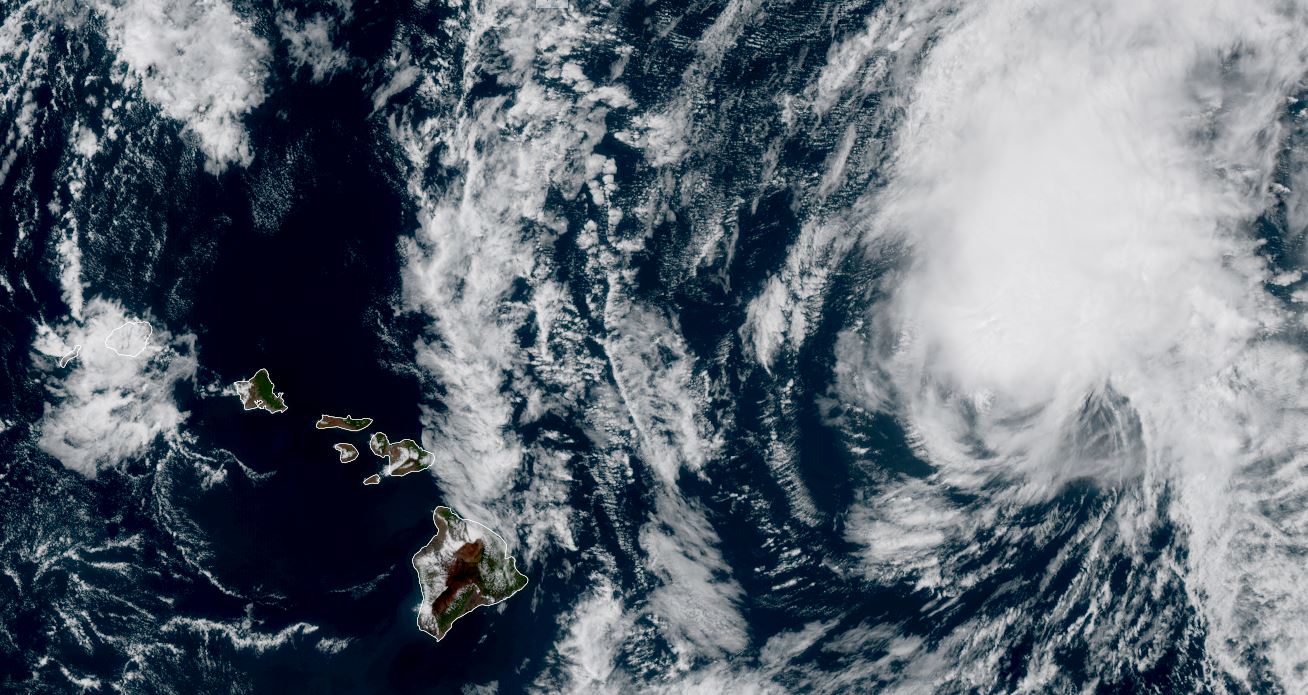
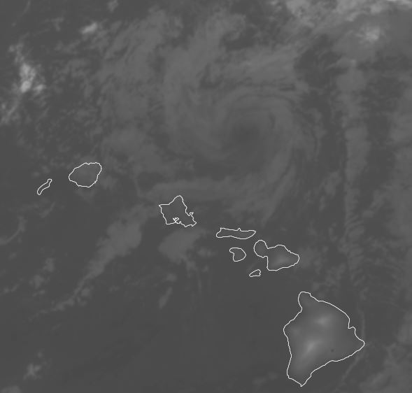
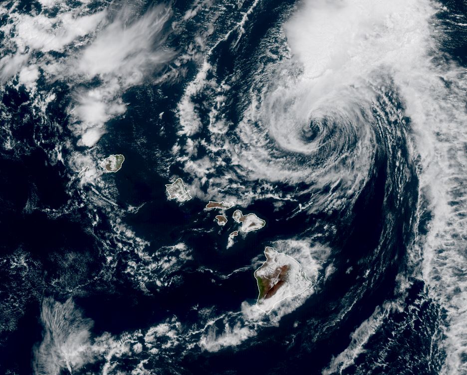
Kiko passing north or the Islands
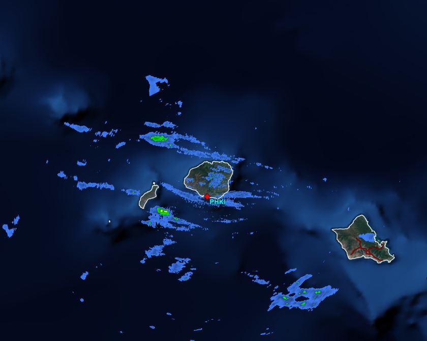
On this early morning, just after midnight - Hawaiian time - Satellite imagery shows Kiko passing to the north of the Islands. IR imagery shows a low level swirl with no convection. The latest radar from after midnight is showing a few showers near Kauai.
The Weather Situation
SUMMARY OF 1100 PM HST...0900 UTC...INFORMATION
-----------------------------------------------
LOCATION...22.4N 157.1W
ABOUT 90 MI...145 KM NE OF HONOLULU HAWAII
MAXIMUM SUSTAINED WINDS...40 MPH...65 KM/H
PRESENT MOVEMENT...W OR 280 DEGREES AT 13 MPH...20 KM/H
MINIMUM CENTRAL PRESSURE...1008 MB...29.77 INCHES
Tropicast: IR RAMMB/CIRA slider GOES 18
 Tropicast: Visible RAMMB/CIRA slider GOES 18 Tuesday Late Afternoon
 Tropicast: Radar 12:40 am HST
 Tropical Weather Forecast:
Kiko will continue to parallel the NW Hawaiian islands today and weaken into a tropical depression. Surf will continuing subsiding.
Re: Kiko
Posted: Wed Sep 10, 2025 8:12 pm
by Tropical Inspector
Wednesday Evening Update
Remnants of Kiko NNW of Islands
It is interesting that Kiko was deemed a post tropical low on the 5 am HST advisory this morning as no convection was associated with the low. Since that time several hours ago, a resurgence of convection has built. IMO, is that Kiko remains at least a depression or possible minimal storm level.
Tropicast: Visible RAMMB/CIRA slider GOES 18