Nate

Tropical cyclone archives for the 2017 Atlantic hurricane season
Post Reply
User avatar
Tropical Inspector
Site Admin
Site Admin
Posts: 3694
Joined: Tue Feb 20, 2007 2:28 pm
Antispam: no
Location: Under a palm tree
Contact:

Nate

Post by Tropical Inspector »

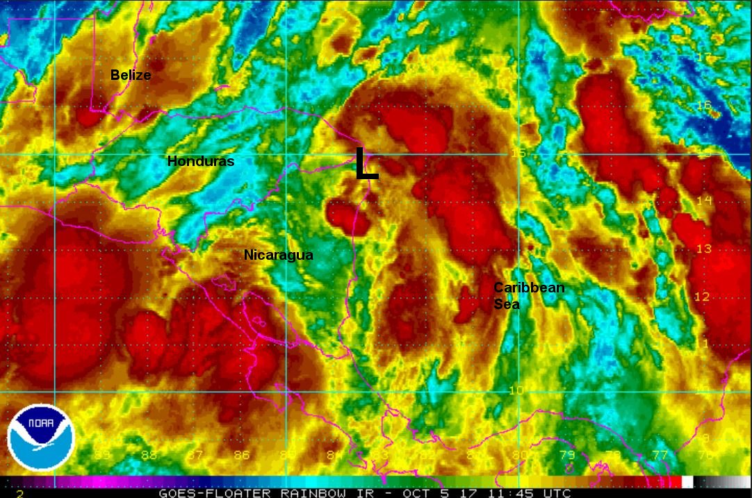
Wedesday Midday Update

Tropical Depression 16 classified

The Weather Situation
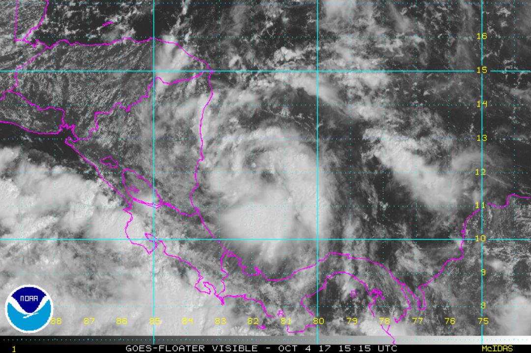
Spin is noted on satellite imagery east of Nicaragua. Deep convection is also present, so it is very likely that tropical storm strength will be reached soon. Heavy rainfall and mudslides are possible on the Central American countries.

Current Tropical Weather
As of 11:00 AM EDT TD 16 was centered at 12.2 N / 81.9 W or 25 miles SSE of San Andres Island. It was moving NW at 7 mph. Top sustained winds are estimated at 35 mph. Pressure was estimated at 1005 MB.

Tropical Weather Forecast:
TD 16 is forecast to move along the eastern coast of Central America and near the eastern edge of the Yucatan. It will then move over the southern Gulf by this weekend and make landfall by early Sunday AM along the northeastern or central gulf coast, possibly as a hurricane.

Tropicast: Visible Satellite
Image
Rich Johnson
Twitter: https://twitter.com/richjohnsonwx
Certified Broadcast Meteorologist - Hurricane Expert
User avatar
Tropical Inspector
Site Admin
Site Admin
Posts: 3694
Joined: Tue Feb 20, 2007 2:28 pm
Antispam: no
Location: Under a palm tree
Contact:

Re: Nate

Post by Tropical Inspector »

Thursday Morning Update

Nate classified

The Weather Situation
Nate is near the coast of northeastern Nicaragua. Deep convection is disorganized and is mostly to the east over the western Caribbean. Heavy rainfall will continue over Central America with the risk of mudslides.

Current Tropical Weather
As of 8:00 AM EDT Nate was centered at 13.9 N / 83.4 W or 10 miles south of Puerto Cabezas, Nicaragua. It was moving NW at 8 mph. Top sustained winds are estimated at 40 mph. Pressure was estimated at 999 MB.

Tropical Weather Forecast:
Forecast models have shifted west. Nate will be interacting with the land over Central America and the Yucatan through early Saturday. This will keep the tropical cyclone disorganized. It will move into the southern Gulf Saturday morning and make landfall on the north Gulf coast by Sunday AM.

The European is now following the GFS model. Both show a weak system (tropical storm) making landfall. NHC is keeping Nate a hurricane due to the fact that warm water and weak shear will allow strengthening. Forecast models many times have a difficult time providing accurate tracks when a system is weak as Nate is now. :arrow: Continue to follow the latest trends.

Tropicast: IR Satellite
Image
Rich Johnson
Twitter: https://twitter.com/richjohnsonwx
Certified Broadcast Meteorologist - Hurricane Expert
User avatar
Tropical Inspector
Site Admin
Site Admin
Posts: 3694
Joined: Tue Feb 20, 2007 2:28 pm
Antispam: no
Location: Under a palm tree
Contact:

Re: Nate

Post by Tropical Inspector »

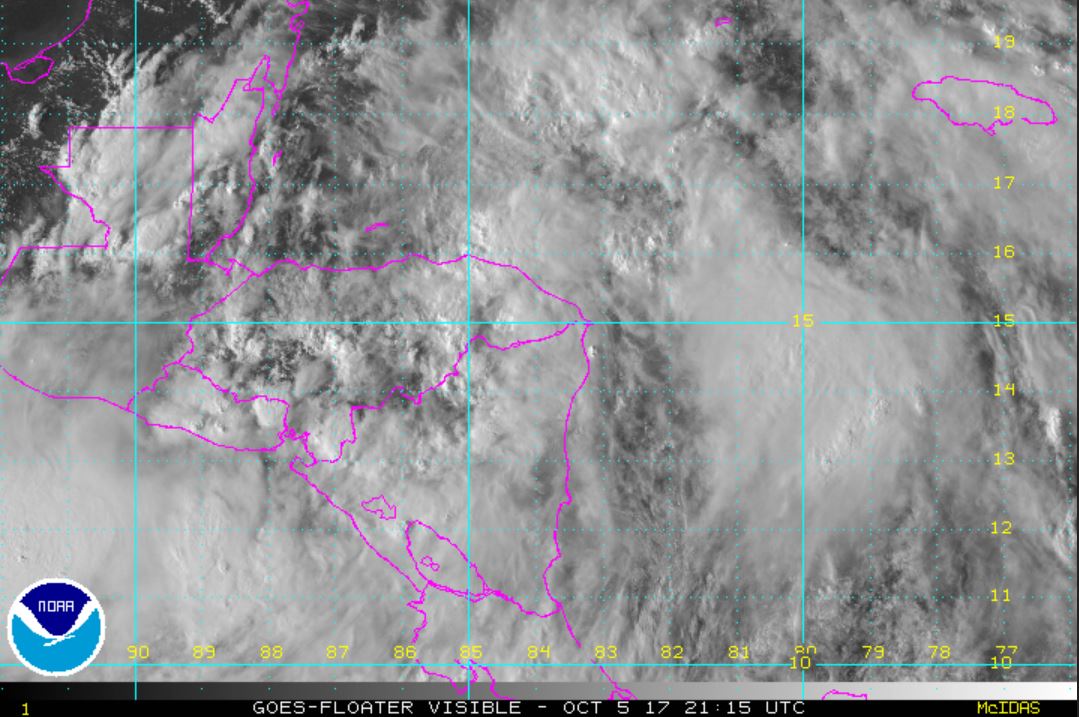
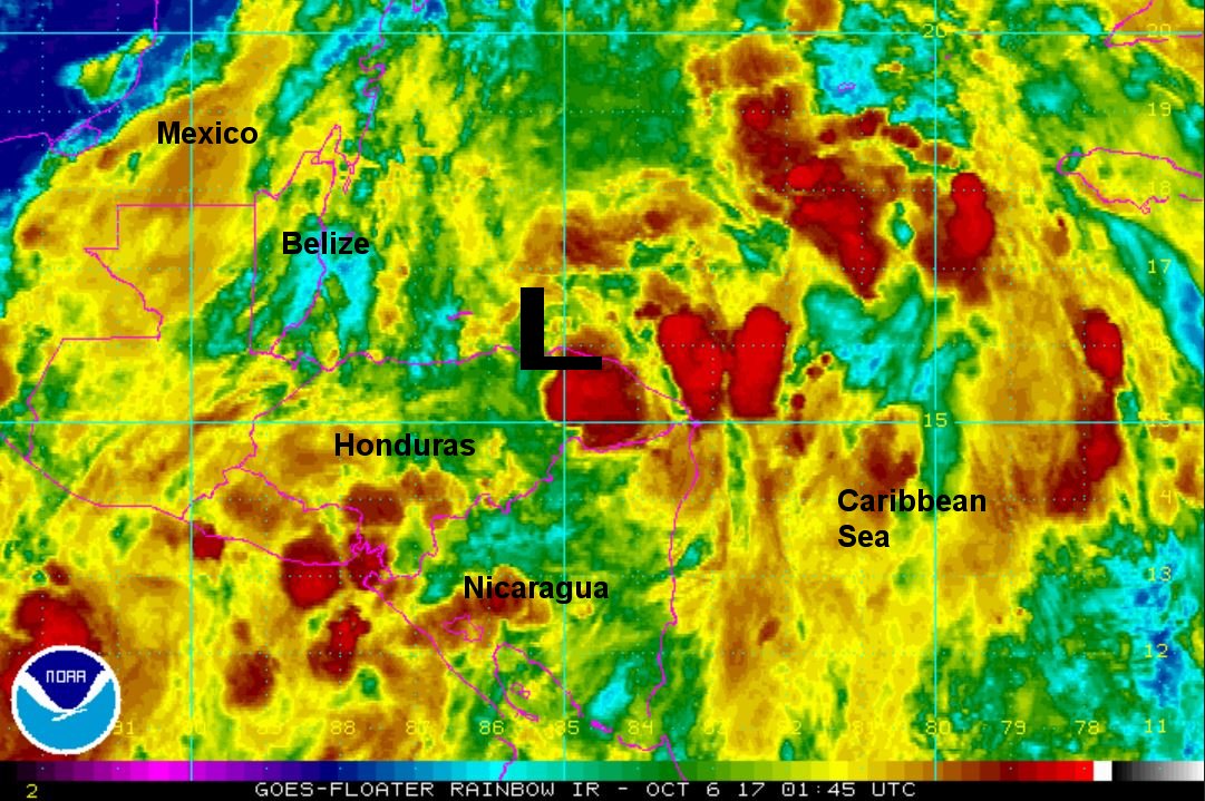
Thursday Night Update

Nate disorganized

The Weather Situation
Nate remains disorganized tonight. The circulation is just moving north of the Honduras coast. Some organization will likely occur over water before moving over the Yucatan by late Friday.

Current Tropical Weather
As of 8:00 PM EDT Nate was centered at 15.3 N / 84.5 W or 390 miles SSE of Cozumel, Mexico. It was moving NNW at 10 mph. Top sustained winds are estimated at 40 mph. Pressure was estimated at 1000 MB.

Tropical Weather Forecast:
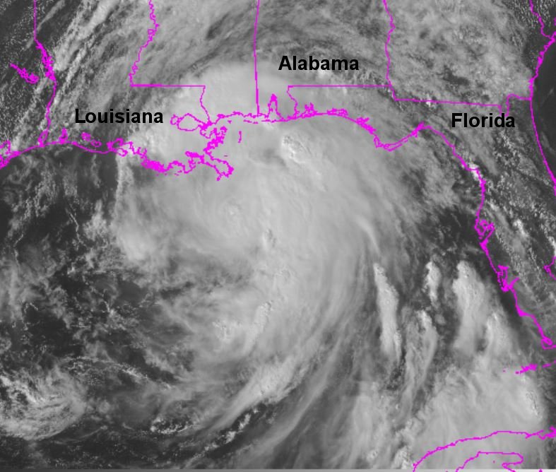
Forecast models continue not to strengthen Nate much before landfall by Sunday morning on the Louisiana coast. NHC continues to predict Nate to become a category 1 hurricane by landfall. This is based on model indicating possible rapid strengthening.

Tropicast: Visible Satellite Thursday Afternoon
Image

Tropicast: IR Satellite
Image
Rich Johnson
Twitter: https://twitter.com/richjohnsonwx
Certified Broadcast Meteorologist - Hurricane Expert
User avatar
Tropical Inspector
Site Admin
Site Admin
Posts: 3694
Joined: Tue Feb 20, 2007 2:28 pm
Antispam: no
Location: Under a palm tree
Contact:

Re: Nate

Post by Tropical Inspector »

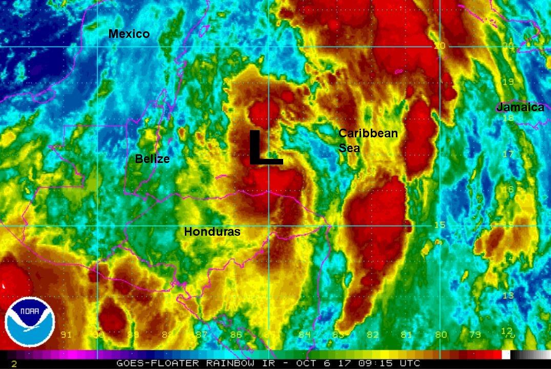
Friday Morning Update

Nate strengthening

The Weather Situation
Nate is now back over the Caribbean, north of eastern Honduras / east of Belize. Deep convection is returning around the center and further development is likely today. Nate may be hindered later today depending on how much of the circulation interacts with the Yucatan. Heavy rainfall continues over Central America and Cuba and will soon begin over the Yucatan.

Current Tropical Weather
As of 5:00 AM EDT Nate was centered at 16.9 N / 85.1 W or 275 miles SSE of Cozumel, Mexico. It was moving NNW at 14 mph. Top sustained winds are estimated at 45 mph. Pressure was estimated at 999 MB.

Tropical Weather Forecast:
Forecast models did not change over night on track, but have increased forward speed. They continue not to strengthen Nate much before landfall by Saturday night on the Louisiana coast as a tropical storm. NHC continues to predict Nate to become a category 1 hurricane by landfall. This is based on models indicating possible rapid strengthening.

Tropicast: IR Satellite
Image
Rich Johnson
Twitter: https://twitter.com/richjohnsonwx
Certified Broadcast Meteorologist - Hurricane Expert
User avatar
Tropical Inspector
Site Admin
Site Admin
Posts: 3694
Joined: Tue Feb 20, 2007 2:28 pm
Antispam: no
Location: Under a palm tree
Contact:

Re: Nate

Post by Tropical Inspector »

Friday Evening Update

Nate east of Yucatan

The Weather Situation
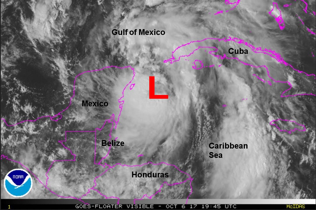
Nate is picking up forward speed and deep convection is building near the center of circulation. It appears that the center will either move near the eastern tip of the Yucatan or through the Yucatan channel. Either way, impacts from land will likely be minimal as the circulation moves quickly into the southern Gulf of Mexico tonight. A recent buoy report indicated a wind gust to 67 mph not far from the low center.

Current Tropical Weather
As of 5:00 PM EDT Nate was centered at 20.3 N / 85.7 W or 80 miles east of Cozumel, Mexico. It was moving NNW at 21 mph. Top sustained winds are estimated at 60 mph. Pressure was estimated at 993 MB.

Tropical Weather Forecast:
Forecast models still show the same scenario this afternoon. They continue not to strengthen Nate much before landfall by Saturday night on the Louisiana coast as a tropical storm. NHC continues to predict Nate to become a category 1 hurricane by landfall. This is based on models indicating possible rapid strengthening. Recent buoy reports showing strengthening suggest that the models may be too low with wind predictions.

Tropicast: Visible Satellite
Image
Rich Johnson
Twitter: https://twitter.com/richjohnsonwx
Certified Broadcast Meteorologist - Hurricane Expert
User avatar
Tropical Inspector
Site Admin
Site Admin
Posts: 3694
Joined: Tue Feb 20, 2007 2:28 pm
Antispam: no
Location: Under a palm tree
Contact:

Re: Nate

Post by Tropical Inspector »

Friday Night Update

Nate in Yucatan Channel

The Weather Situation
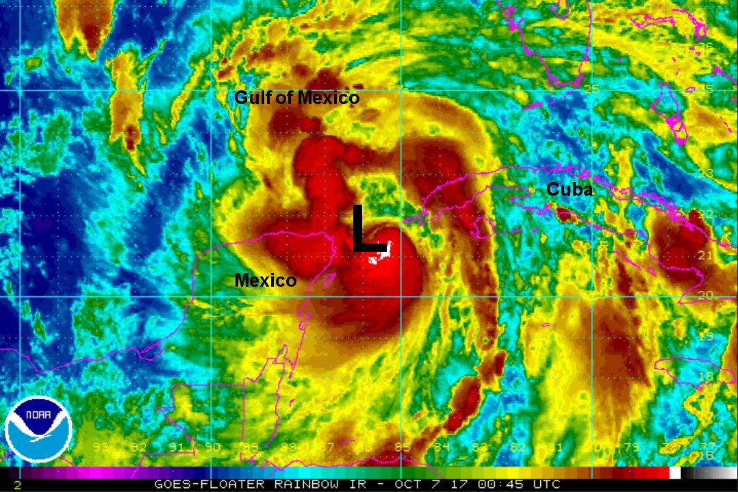
Deep convection continues to build near Nate's center and it is possible that it may become a hurricane earlier than NHC's forecast. Nate also is moving through the Yucatan channel which will minimize any effects that would disrupt the circulation.

Current Tropical Weather
As of 9:00 PM EDT Nate was centered at 21.6 N / 86.0 W or 110 miles NE of Cozumel, Mexico. It was moving NNW at 22 mph. Top sustained winds are estimated at 65 mph. Pressure was estimated at 990 MB.

Tropical Weather Forecast:
Forecast models are a little farther east taking Nate into eastern Louisiana / Mississippi by Saturday night into Sunday morning. NHC continues to make Nate a hurricane which looks reasonable. Models still do not strengthen the system much which doesn't fit the current trend. Nate will track into central Alabama by Sunday midday.

Tropicast: IR Satellite
Image
Rich Johnson
Twitter: https://twitter.com/richjohnsonwx
Certified Broadcast Meteorologist - Hurricane Expert
User avatar
Tropical Inspector
Site Admin
Site Admin
Posts: 3694
Joined: Tue Feb 20, 2007 2:28 pm
Antispam: no
Location: Under a palm tree
Contact:

Re: Nate

Post by Tropical Inspector »

Saturday Morning Update

Nate moving rapidly north

The Weather Situation
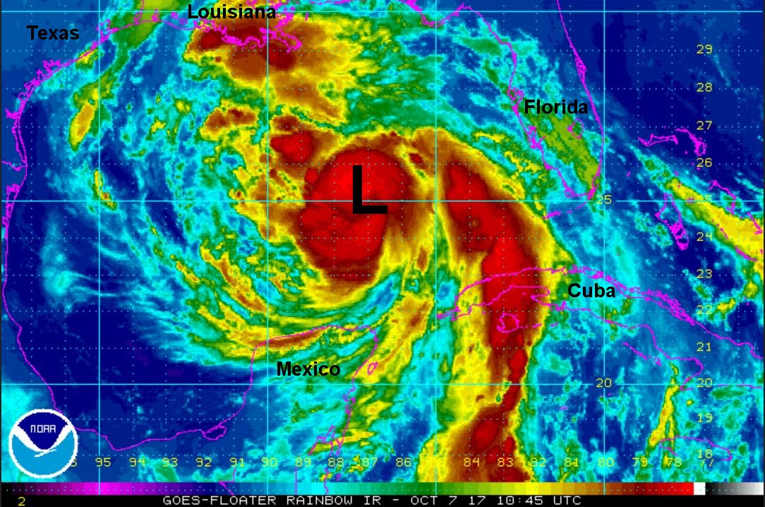
Nate is picking up forward speed. Deep convection has built around the center and some further strengthening is possible today. Effects of storm surge / heavy rainfall / strong winds and isolated tornadoes will be seen. Surge concern will be near and east of where the center of circulation moves on shore.

Current Tropical Weather
As of 7:00 AM CDT Hurricane Nate was centered at 25.7 N / 88.0 W or 245 miles SSE of the Mouth of the Mississippi. It was moving NNW at 22 mph. Top sustained winds are estimated at 85 mph. Pressure was estimated at 986 MB.

Tropical Weather Forecast:
Forecast models did not perform well with the intensity of Nate. Models continually have under forecast strength. NHC's rapid deepening models served well, more closely indicating the intensity. Nate will make one or two landfalls late today. The first may be on the extreme SE coast of Louisiana late today / this evening, and the second on the Mississippi coast tonight.

Tropicast: IR Satellite
Image
Rich Johnson
Twitter: https://twitter.com/richjohnsonwx
Certified Broadcast Meteorologist - Hurricane Expert
User avatar
Tropical Inspector
Site Admin
Site Admin
Posts: 3694
Joined: Tue Feb 20, 2007 2:28 pm
Antispam: no
Location: Under a palm tree
Contact:

Re: Nate

Post by Tropical Inspector »

Saturday Evening Update

Nate approaching north Gulf coast

The Weather Situation
Nate does not appear to be strengthening further as it approaches landfall this evening. Nate should make landfall as a category 1 hurricane. Heavy rainfall is now covering SE Louisiana and parts of the Mississippi and Alabama coast.

Current Tropical Weather
As of 4:00 PM CDT Hurricane Nate was centered at 28.4 N / 89.1 W or 50 miles south of the Mouth of the Mississippi / 140 miles south of Biloxi. It was moving NNW at 23 mph. Top sustained winds are estimated at 90 mph. Pressure was estimated at 981 MB.

Tropical Weather Forecast:
Nate will make landfall near the Mississippi coast tonight. It will weaken to a tropical storm over central Alabama and recurve into eastern Tennessee by Sunday night.

Tropicast: Visible Satellite
Image
Rich Johnson
Twitter: https://twitter.com/richjohnsonwx
Certified Broadcast Meteorologist - Hurricane Expert
User avatar
Tropical Inspector
Site Admin
Site Admin
Posts: 3694
Joined: Tue Feb 20, 2007 2:28 pm
Antispam: no
Location: Under a palm tree
Contact:

Re: Nate

Post by Tropical Inspector »

Nate is weakening and it is very likely not a hurricane. Buoy data and recon data to not support the strong winds claimed by NHC. Stay vigilant.

SELECTED PRELIMINARY STORM TOTAL RAINFALL IN INCHES THROUGH 11
PM EDT 10-8

...ALABAMA...
DIXON 6.94
FOLEY 6.54
ELBA 1 NNW 5.55
MOBILE 4.91
LEE 1 E 4.80
LOWRY MILL 4.68
BIRMINGHAM 2.81
WEDOWEE 2.60

...FLORIDA...
CRESTVIEW 8.32
HURLBURT FIELD 4.34

...GEORGIA...
BRASSTOWN 5.18
SKY VALLEY 4.97
UNION 3 SSW 4.86
ANNA RUBY FALLS 3 N 4.82
CHOESTOE 4.34
LOOKOUT MOUNTAIN 4.19
HIGDONS STORE 4.14
THOMASVILLE 2.38
SMYRNA 2.19
DALTON 2.11

...KENTUCKY...
GREENVILLE 6 SSW 6.12
HOPKINSVILLE 5.72
EDDYVILLE 5 S 5.28
LEITCHFIELD 5.02
BAIZETOWN 3 ESE 4.90
MADRID 3 S 4.63
BENTON 4.60
ROCHESTER 1 NNW 4.40
CLERMONT 1 N 4.17
CHAPLIN 3 ENE 4.14
TONNIEVILLE 3 NW 4.06
BALLTOWN 2 SW 4.03

...LOUISIANA...
NEW ORLEANS/LAKEFRONT ARPT 1.13

...MISSISSIPPI...
BILOXI KEESLER AFB 4.56

...NORTH CAROLINA...
GREAT FALLS 11.62
BEAR CREEK 11.17
HOGBACK 10.48
HIGHLANDS 9.37
RIDGECREST 6.82
CHESTNUT FLATS 6.80
SANDY FLATS 6.58
COWEE FD 5.99
BEAVER CREEK 5.64

...OHIO...
MILL CREEK 3.48
HOPEVILLE 2.64

...TENNESSEE...
HIXSON 5.36
SOUTH PITTSBURG 4.52
GROTTO FALLS 4.51
MILE STRAIGHT 3.52
COALMONT 2.67
Rich Johnson
Twitter: https://twitter.com/richjohnsonwx
Certified Broadcast Meteorologist - Hurricane Expert
Post Reply

Return to “2017 Atlantic Hurricane Season Archives”

Who is online

Users browsing this forum: No registered users and 1 guest